The Annapurna Circuit Trek is one of the best treks in Nepal, if not the world–although road construction in the last two decades has had a significant impact on the trekking experience (more on this later). Note: if you’re a mountain biker, the road on the west side is one of the most exciting and scenic mountain biking experiences!
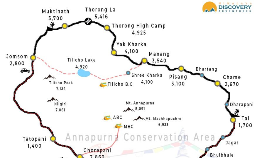
The trek starts at Jagat or Dharapani (approx. 8 hrs drive from Kathmandu) and ends in the Kali Gandaki Gorge– the disputed highest gorge in the world between Dhaulagiri (8,176 meters) and Annapurna (8,091 meters)
For acclimatization reasons, the circuit is followed by an anti-clockwise trail that circumvents the Annapurna Massif and takes trekkers through Central Nepal’s Annapurna, Manang and Mustang region. At its peak, the trek crosses the Thorong La Pass (5,416 meters) and descends to the town of Muktinath.
The road construction activities that began in 2004 and completed in 2008/9 have had a measurable impact on the trekking experience of the Annapurna circuit.
The Nepalese government realized that the route had a negative impact on hiking tourism on both the western (Pokhara-Muktinath) and eastern (Chame-Manang) sides of the circuit and created a series of New Annapurna Trekking Trails. These NATT trails, marked blue and white or red and white, take trekkers off the dusty and unpleasant roads and enjoy a much more pleasant walk.
The Annapurna circuit typically takes 10 – 17 days to complete (depending on whether you decide to take a detour to the Annapurna Base Camp and the Annapurna Sanctuary) and covers 150 – 240 km (depending on when you decide to stop the tour or use transport vehicles).
The scenery on the Annapurna Circuit is exceptionally beautiful, with trekkers crossing rice-terraced paddy fields, subtropical forests and glacial surroundings. There are a number of major mountains, including the Annapurna Massif (I-IV), three 8,000m peaks–Dhaulagiri (8,176m), Manaslu (8,156m) and Annapurna I (8,091m) and numerous 6,000 to 7,000m peaks.
Detailed Annapurna Circuit Trek Map
The Himalayan Map house, New Annapurna Trekking Trails map & Annapurna Circuit Trek map, which can be purchased in Kathmandu, Pokhara or online.
Please note: The classic Annapurna circuit has been severely affected by the road from Muktinath to Jomsom. If you choose to walk this route, be prepared for an unpleasant and dusty experience, as you wiz jeeps. Fortunately, the New Annapurna Trekking Trails (NATT-trails) offer alternatives. We suggest the following route if you are not on a set trip.
Trek to the beautiful town of Kagbeni (2,800 meters) for an overnight stay. We recommend taking the high trail via Jhong from Muktinath, as it offers better views of the mountains.
From Jomsom take the new NATT- trail (marked in red and white) to Marpha (2,665m), where you can stay overnight and then continue along the route from Jomsom/Marpha below. Though, we highly recommend not skipping Kagbeni.
If you run out of time, you can also get a bus or jeep from Muktinath to Pokhara. If you are a fanatic of mountain biking, you can rent a mountain bike for one of the most amazing rides down and out of Muktinath this area of Nepal is rapidly becoming a famous mountain biking routes.
Annapurna Route Variations.
If you have much time on the Annapurna Circuit, you might want to consider the Poon Hill Trek, the Mardi Himal Trek or Annapurna Base Camp Trek.
Conclusion
Trekking in Annapurna is a classic trip with all aspects for a classic trek and a great adventure. This trek is perfect for adventure seekers.
Do you have any question about trip to Nepal?
Tell us about your trip to Nepal and what you expect from it. We will answer your questions in 24 hours and help you design a trip with a comfortable itinerary to best meet your needs.


